Blog

July 11, 2024 0 Comments

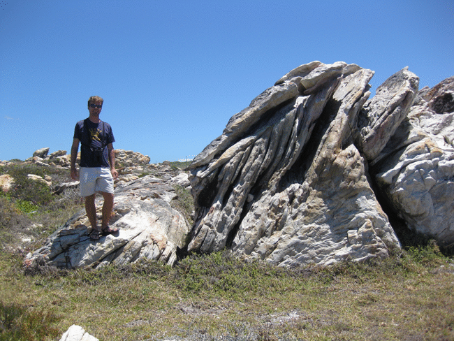
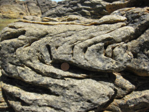
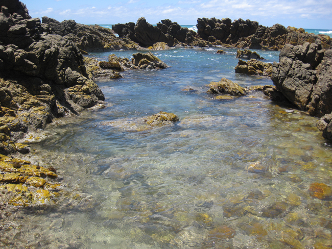
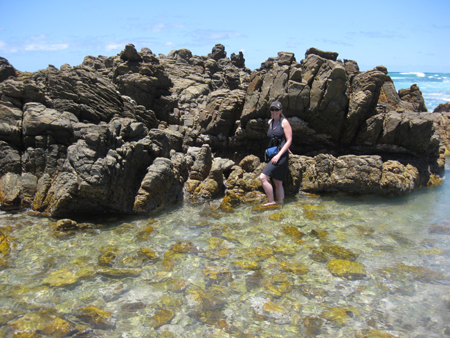
The mixed-up quartzites of Cape Agulhas

Here, we examine what you will see if you visit the southernmost point of the African continent. There are various protuberances of land in southern South Africa, each of which is a “cape” with its own proper name. The Cape of Good Hope is probably most famous by virtue of its awesome, mythological-sounding name and its proximity to the urban center of Cape Town, but there are others, too. For instance, Cape Point is only a kilometer or two from the Cape of Good Hope. On the other side of False Bay, there is Cape Hangklip, and beyond that a ways lies the object of this case study, Cape Agulhas:

There is a plaque there showing that this is Africa’s southernmost point, and pointing east to the Indian Ocean, and west to the Atlantic Ocean:

Lorem ipsum dolor sit amet, consectetur adipiscing elit. Ut elit tellus, luctus nec ullamcorper mattis, pulvinar dapibus leo.

The word “Agulhas” means “needles,” a Portuguese reference to the fact that when it was named in the year 1500, the cape was about where magnetic declination was 0°; in other words, the longitude at which magnetic north and true north were the same. (Since the magnetic pole wanders, however, this name is no longer as accurate as it was half a millennium ago.)

It is a pretty enough place, as you can see in the images below, but not nearly so striking as Cape Point or the Cape of Good Hope. Cape Agulhas is the southernmost protrusion of  a mildly curving coastline, rocky and wavestruck, but it is not a crisp peninsula or anything like that…

The rocks here are quartzites, though their surface is covered with an assortment of lichens above water and seaweed below, and other encrusting organisms.

Imagine that you visit. You can wade out to one of the small outcrops of quartzite just offshore:

And then you notice something…

Cross-bedding and ripples are part of the same depositional setting, forming in a flowing directional current.

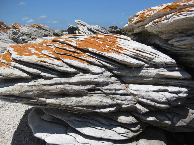
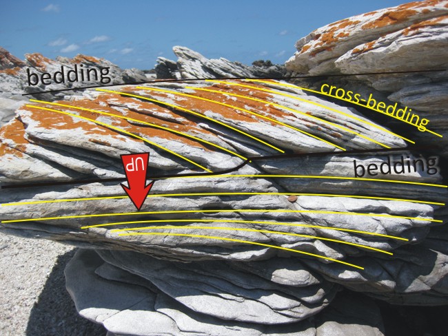
What pattern is apparent in this outcrop? (Ignore the orange lichens growing on it; look deeper into the structure of the quartzite.) Hint: it’s a primary sedimentary structure with geopetal value…

This is cross-bedding, and it’s up-side-down!
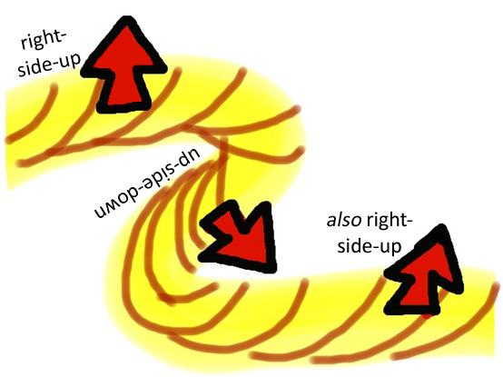
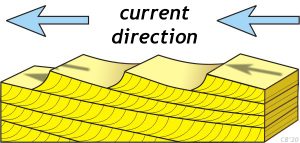
A block diagram showing the formation of ripples and cross-beds. As current flows from right to left across the image (arrows pointing left), a series of ripples form perpendicular to the current flow. The ripples are shallowly sloped to the right (up-current) and steeply sloped to the left (down-current). As sediment accumulates in the low-energy water immediately downstream of the ripples, it forms arcuate (concave-up) mini-layers (cross-beds). As these build out (prograde) over time, they make beds.
Cross-bedding and ripples are part of the same depositional setting, forming in a flowing directional current.

Cross-bedding is formed when layers of sediment are deposited on the leeward side of a ripple or dune that is moving grain by grain in a uni-directional current.

Notice how the cross-beds are at an angle to the main beds, and that the cross-beds are concave-up. They are tangential to the main bed at the bottom (meaning they curve gently to be parallel with the main bed) and they are truncated by the main bed at the top (meaning that they stop at an abrupt angle with the bottom of the overlying bed). In other words, cross-beds look different right-side-up than they do up-side-down. They can thus serve as good geopetal indicators: little geologic clues in stratified rocks about “which way was up” when the beds were deposited.

Looking at this outcrop through the eyes of a geologist, then, you see this:

A few dozen meters away, you find a right-side-up set of cross-beds, inclined steeply to be sure, but not inverted. You can tell this because the cross-beds are concave up, and truncated on their upper surface, and tangential on their lower surface:

This observation piques your interest, and you spend a pleasant half hour in the sunshine, searching around for cross-bedding in different orientations. You’re not bored for long; soon you find a bunch of examples…

Your geological training allowed you to make the observation that sent you off on this quest. If you hadn’t been educated to recognize cross-bedding when you saw it, you likely would have looked at the Cape Agulhas outcrops as “just a bunch of rock.”

So now that the observation has been made, and then validated with additional exploration, you are probably beginning to wonder why. What hypotheses pop into your mind as you glide from outcrop to outcrop, seeing dozens of examples of inverted cross-bedding.

Scroll through these additional examples you encounter:

Previous slide
Next slide

So there are a variety of orientations for the cross-bedding that you observe. How can you explain this?

One solution that unfolds in your mind is that the beds in which the cross-beds are included are themselves in multiple orientations, and in many places overturned. One way to accomplish this is by folding the beds up rather intensely. Like this (sketch drawn on my iPad’s “Whiteboard” app):

Sure enough, once you spend a little time looking around, testing your “folded” hypothesis, you find some confirming evidence; a few tight small scale folds. Applying Pumpelly’s Rule (the notion that small-scale structures mimic and reflect larger-scale regional structures), you deduce that you may be in a zone of folded sedimentary rocks: a ‘fold and thrust belt’ associated with an ancient episode of mountain building.

Indeed, these folds (and the flipped-around beds they deform) are part of the Cape Fold Belt, an east-west trending mountain belt that formed along the southern coast of South Africa when South America mashed into it during the amalgamation of the southern supercontinent Gondwana. These quartzite strata are the same geologic unit that holds up the mesa-like form of Table Mountain immediately south of Cape Town, but here they are much more deformed.

Small-scale fold in quartzite beds at Cape Agulhas.
Folds exposed in a mountainside above Hermanus, South Africa. These strata have been deformed as part of the Cape Fold Belt.
Skip to content